I've known for awhile that our country depends far too much on coal energy, and that the area we live in was a hotspot for the mining, distribution, and burning of it. At first I dismissed that conceptual approach thinking it too expansive and too difficult to pursue. From past experience I knew that photographing coal facilities the way I wanted would be difficult. I'm ashamed to say however, that I wasn't fully aware of the extent of this problem until now. While many of these things are kept surprisingly quiet, a bit more research would have led me to some tragic situations that I wouldn't be able to turn away from. Strip mining, specifically mountaintop removal, and coal sludge impoundments are two of the most environmentally destructive things I've ever seen. Combined with the already severe emissions problem, the dangers of coal power are something that I simply can't ignor
 e.
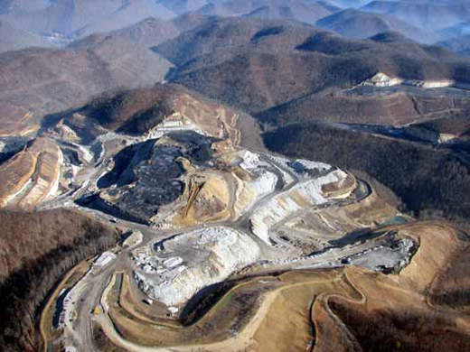
e.Mountaintop removal is a destructive form of coal strip mining that is taking place in the Appalachian mountains of Virginia, West Virginia, Kentucky, and Tennessee. Using 300 million pounds of explosives per day, forested mountaintops are blasted off in order to get to the coal faster and with less labor than with a traditional mine. The trees, vegetation, topsoil, and any other waste, rather than being used, is often dumped into valleys, burying the streams that provide drinking water. The coal is extracted by huge cranes called draglines, costing up to $100 million and displacing the need for hundre
 ds of employed workers. Before transportation, the coal is washed and treated, creating excess sludge or slurry. A mix of water, coal ash, clay, and toxic chemicals such as arsenic, mercury, lead, copper, and chromium, this coal sludge is placed in open impoundments. These 'sludge lakes' are supported by other leftover debris from the operation and are often very unstable. Yet another similar type of waste is created during the actual burning of coal in power plants, consisting of what cannot be combusted. To prevent this toxic ash from entering the atmosphere, it is now collected and held. These waste impoundments have breached in the past, including a horrible instance late last year in Kingston, TN, which has been described as the worst man-made environmental disaster since Chernobyl. I'll go into that in my next topic post. The companies move on after the coal has been exhausted from a mountain, leaving a moonscape in their wake. While reclamation efforts are made, they are often small and no matter what is done the mountains and streams will never recover to their former state.
A quick google map search of the region reveals these sites as huge scars littered across the Appalachian Mountain Range. I circled most of the sites and hotspots where they are clearly visible, even in a map of this scale encasing about 16,000 square miles of Virginia, West Virginia, and Kentucky. Some of the individual sites can be as large as 3 to 5 square miles themselves. I was astonished at the sheer number and size of the sites. Every little blemish or dead, dry looking area in the mountains turned out to be one. Some major cities are also marked, as well as Summersville because it seems to be the closest area to Richmond that is affected. I'm going to try to make it out that way to shoot this week during the break. Here are some closeups of some of the mountaintop removal sites and fly ash sludge impoundments:


Over fall break I'd like to carve a route that takes me down to Kingston, TN to see the spill location and then back up through KY and WV through the majority of the mountaintop removal sites. With some planning I think I can make it that far and come out with quite a bit of material.
http://ilovemountains.org
http://en.wikipedia.org/wiki/Surface_mining
http://www.ohvec.org/galleries/mountaintop_removal/007/
No comments:
Post a Comment